PROPOSED HABITAT PROTECTION CLOSURE
FORT FUNSTON
GOLDEN GATE NATIONAL RECREATION AREA
NATIONAL PARK
SERVICE
GOLDEN GATE NATIONAL RECREATION AREA
CORRECTION TO NOTICE OF PROPOSED YEAR-ROUND CLOSURE AT
FORT FUNSTON
AND REQUEST FOR COMMENTS
CORRECTION: Public comments on this notice must be received by September 18, 2000.
(note: later the deadline was extended to Oct. 6, 2000).
Dated: July 17, 2000.
Brian O'Neill
Superintendent, GGNRA
NATIONAL
PARK SERVICE
GOLDEN GATE NATIONAL RECREATION AREA
NOTICE
OF PROPOSED YEAR-ROUND CLOSURE AT FORT FUNSTON
AND REQUEST
FOR COMMENTS
COMMENTS:
Public comments will be accepted for a period of 60 calendar days from the date
of this notice. Therefore, public comments on this notice must be received by
September 12, 2000. Public comments should be submitted to NPS as early as possible
in order to assure their maximum consideration. Comments will be considered
and this proposal may be modified accordingly, and the final decision of the
National Park Service will be published in the Federal Register.
If individuals submitting
comments request that their name and/or address be withheld from public disclosure,
it will be honored to the extent allowable by law. Such requests must be stated
prominently at the beginning of the comments. There also may be circumstances
wherein the NPS will withhold a respondent's identity as allowable by law. As
always, NPS will make available for public inspection all submissions from organizations
or businesses and from persons identifying themselves as representatives or
officials of organizations and businesses; and, anonymous comments may not be
considered.
SEND COMMENTS
TO: Superintendent, Golden Gate National Recreation Area, Bay and Franklin
Streets, Building 201, Ft. Mason, San Francisco, 94123.
FURTHER INFORMATION:
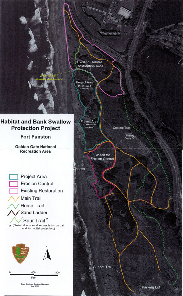
Detailed information concerning this proposal, including a map
depicting the closure
area and open park trails, is available at the following locations:
CONTACT: For further
information, contact Scalla Sheen, Office of Public Affairs, GGNRA at 415
561-4730.
Dated - July
14, 2000.
Brian ONeill
Superintendent, GGNRA
As part of the resource
protection mission of the National Park Service (NPS), approximately 12-acres
of Fort Funston is being closed year-round to off-trail recreational use by
the public. This action will protect habitat for a nesting colony of California
state-threatened bank swallows (Riparia riparia), a migratory bird species once
more common along the California coast that has declined significantly due to
habitat conversion and increased recreational use. This closure is also necessary
to enhance significant native plant communities, improve public safety, and
reduce human-induced impacts to the coastal bluffs and dunes, a significant
geological feature.
Part of the Golden Gate
National Recreation Area (GGNRA), Fort Funston spans approximately 230 acres
along the coastal region of the northern San Francisco peninsula. It is located
south of Ocean Beach and north of Pacifica, and is flanked to the east by both
John Muir Drive and Skyline Boulevard, and to the west by the Pacific Ocean.
The proposed year-round closure is located within the northern region of Fort
Funston and is depicted on the attached map as "Project Area (Year-round closure)."
It is defined to the west by the edge of the coastal bluffs; to the east by
the Coastal Trail; to the north by protective fencing installed in the early
1990s for habitat protection; and to the south by a pre-existing "beach access"
trail west of the Battery Davis "Y". There is currently fencing erected around
the eastern and northern perimeters of the proposed year-round closure area.
Additional fencing will be erected along the southern boundary, parallel to
the "beach access" trail (see map). This fencing will be peeler post and wire
mesh design, consistent with the existing fencing that was erected in February-April
2000.
The entire 12-acre project
area will be closed year-round to visitor access. There is a portion of one
designated trail located within the footprint of this closure. This trail, known
as the "Spur trail" (see map), will be closed to visitor use because southern
sections of this trail have become unusable due to increased sand deposition
on the trail surface. This has compounded the establishment and use of unauthorized
"social" trails in the northern section of the project area. Visitor use of
and access to all "social" trails including "the Gap" (see map) within the project
footprint will be prohibited by this closure.
II.
HISTORY - Fort Funston
Prior to Fort Funston's
purchase by the Army, the site supported a diversity of native dune vegetation
communities. During the 1930s however, the Army built an extensive system of
coastal defense batteries, drastically altering the dune topography east of
the bluffs and, in the process, destroying much of the native plant communities
that inhabited the dunes. Following construction, the Army planted iceplant
(Carpobrotus edulis) in an attempt
to stabilize the open sand around the batteries.
By the mid-1960s, extensive
areas of Fort Funston were covered with invasive exotic plants such as iceplant
and acacia. Some years after Fort Funston was closed as a military base, it
was transferred to the National Park Service in 1972 to become part of the GGNRA.
As a unit in the national park system, Fort Funston today is used extensively
by beachcombers, walkers, hang gliders, paragliders and horseback riders, and
other recreational users. Approximately three-quarters of a million visitors
enjoy Fort Funston annually.
III.
CLOSURE JUSTIFICATION
This closure is necessary
to protect habitat for the California State-threatened bank swallows (Riparia
riparia), enhance significant native plant communities, improve public safety
and reduce human-induced impacts to the coastal bluffs and dunes, a significant
geological feature. The National Park Service has authority to effect closures
for these purposes pursuant to Section 1.5 of Title 36 of the Code of Federal
Regulations. Specifically, Section 1.5 authorizes the Superintendent to effect
closures and public use limits within a national park units (sic)
when necessary for the maintenance of public health and safety, protection of
environmental or scenic values, protection of natural or cultural resources,
aid to scientific research, implementation of management responsibilities, equitable
allocation and use of facilities, or the avoidance of conflict among visitor
use activities. As discussed in detail below, the proposed closure at
A. The Threatened Bank
Swallow
One of the many unique features of Fort Funston is that it supports one of the
last two remaining coastal
cliff-dwelling colonies in California for the bank swallow (Riparia riparia).
Once more abundant throughout
the state, their numbers have declined so dramatically that in 1989 the State
of California listed the bank
swallow as threatened under the California Endangered Species Act. The bank
swallow is also a protected
species under the Migratory Bird Treaty Act, and for nearly a century, the bank
swallows have returned
to Fort Funston each March or April to nest and rear their young along the steep
bluff faces. NPS regulations,
policies and guidelines mandate the protection and preservation of this unique
species and its habitat.
Its preferred habitat --
sheer sandy cliffs or banks -- has been altered throughout its range by development,
eliminated by river channel stabilization, and disrupted by increased recreational
pressures. The Fort Funston colony is particularly unique in that it is one
of only two remaining colonies in coastal bluffs in California, the other being
at A�o Nuevo State Park in San Mateo County. Bank swallow habitat at A�o Nuevo
remains closed to visitor access.
Mortality of bank swallows
results from a number of causes including disease, parasites and predation.
Destruction of nest sites, including collapsed burrows due to natural or human-caused
sloughing of banks, appears to be the most significant direct cause of mortality
(Recovery Plan, Bank Swallow (Riparia riparia), State of California Department
of Fish and Game 1992). The Recovery Plan recommends a habitat preservation
strategy through protection of lands known to support active colonies or with
suitable habitat features for future colony establishment. It also acknowledges
that isolated colonies, like Fort Funston, are at particularly high risk of
extinction or severe population decline. Additionally, the State of California
Historic and Current Status of the Bank Swallow in California report (1988)
recommended that nesting colonies be protected from harassment and human disturbance.
The Fort Funston colony
has been recorded since at least 1905. Records indicate that the colony fluctuated
in size and location overtime. A 1961 study of the Fort Funston colony documented
a total of 84 burrows in 1954, 114 in 1955, 157 in 1956, and 196 in 1960. GGNRA
staff counted at least 229 burrows in 1982 and more than 550 in 1989. In 1987
the California Department of Fish and Game documented 417 burrows at Fort Funston.
Approximately 40 to 60 percent of burrows are actively used for nesting in a
given year.
Between 1992 and 1995,
NPS implemented other protection and restoration measures for the Fort Funston
colony, including a year-round closure of approximately 23-acres in the northern
most portion of Fort Funston to off-trail recreational use. The current proposed
closure area lies directly south of this previous closure area. From 1954-56
and from 1989-97, the colony was located along the bluffs within the footprint
of this previous closure. However the colony shifted during 1959 and 1960, and
again since 1998, such that birds are now nesting within the current proposed
closure area.
In 1993,GGNRA established
an annual monitoring program to track the abundance and distribution of bank
swallows at Fort Funston. Trained personnel conduct weekly surveys during nesting
season (from mid-April through early August). From 1993 to 1996, burrow numbers
were over 500 each year. The number declined dramatically to only 140 in 1998
and 148 in 1999 when the colony shifted to the current proposed closure area
(then unprotected). This event coincided with the storms during the winter of
1997 that caused significant cliff retreat and slumping. In an attempt to protect
the colony from recreational disturbance of nesting habitat, protective fencing
was installed along the bluff top in 1998 with interpretive signs to encourage
visitors to reduce impacts on the nesting colony. These efforts proved unsuccessful
in preventing recreational disturbance to the colony. NPS observed increased
erosion due to visitor use adjacent to the fenceline. Moreover, the rate of
natural bluff erosion, approximately one foot per year, and the constant deposition
and erosion of sand material caused the fence to collapse and fail within just
a few months. Fence posts near the bluff face also provided advantages to swallow
predators that perch on the posts with a view to the swallow nests.
A wide array of disturbances to
the swallows at Fort Funston have been observed and recorded during monitoring,
and/or photo-documented. While bank swallows are known to be quite tolerant
to some disturbance, few colonies are subjected to the intense recreational
pressure at Fort Funston. Documented disturbance events at Fort Funston include:
cliff-climbing by people and dogs; rescue operations of people and dogs stuck
on the cliff face; people and dogs on the bluff edge or in close proximity to
active burrows; graffiti carving in the cliff face; aircraft and hang-glider
over-flights; and discharge of fireworks within the colony. The potential impacts
from such disturbances include: interruption of normal breeding activity, such
as feeding of young; crushing of burrows near the top of the cliff face (nests
can be located within a foot of the bluff top); casting shadows that may be
perceived as predators; accelerating human-caused bluff erosion; and active
sloughing and land-slides that may block or crush burrows and the young inside.
The NPS has determined
that the designated trails (see map) at Fort Funston provide adequate access
to the park area and that continued use of unauthorized "social" trails within
the project footprint has adverse impacts on park resources, including the bank
swallow.
The institution of the
proposed 12-acre closure area, coupled with increased interpretive signs and
strategically located protective barriers at the base of the bluffs will protect
the bank swallow colony by preventing most of these disturbances. There will
be no visitor access to the bluff edges above the nesting sites, thus preventing
falls and rescues on the cliff face, as well as human-induced erosion, crushing
of burrows, and casting of shadows. Visitor access up the bluffs from the beach
into the closure area will be prohibited, thus avoiding human-induced erosion
of the bluffs and habitat disturbance.
B. Geology
and Erosion
The bluffs at Fort
Funston provide one of the best continuous exposures of the last 2 million years
or more of geologic history
in California, covering the late Pliocene and Pleistocene eras. This exposure
of the Merced Formation
is unique within both the Golden Gate National Recreation Area and the region.
It is a fragile, nonrenewable
geologic resource. NPS regulations, policies and guidelines mandate
preservation of such resources
by preventing forces (other than natural erosion) that accelerate the loss
or obscure the natural features
of this resource.
Recreational use along
the bluff top contributes to a different type of erosion than the natural processes
of undercutting and slumping. Concentrated wave energy at the base of the bluffs
naturally leads to bluff retreat typically occurring during winter season when
the bank swallows that nest in the vertical bluff faces are absent. Natural
weathering and erosion from rainfall runoff and wind contribute to loss of the
bluff face. During spring and summer, when park users clamber around the bluff
top, erosion occurs from the top to the bottom, compromising the bluff face.
Slumps caused by heavy visitor traffic along the bluff top can induce sand slippage
and may even wipe out burrows during nesting season. Geologist Clyde Warhaftig
described areas of this unique sand bluff formation as crushable with the fingers
and indicated, in 1989, that people climbing the cliff faces would induce additional
erosion and that such activity should be prevented.
Additionally, erosion has
been both documented and observed throughout the inland topography of the closure
area. Continued heavy visitor use in this inland dune bluff area and associated
human-caused erosion along unauthorized "social" trails is likely to further
shorten the lifespan of the bluffs, an additional threat to the long-term existence
and sustainability of suitable habitat for the Fort Funston bank swallow colony.
The proposed closure will
preserve the unique bluffs by preventing destructive human activity around the
bluff tops and permitting the inland dune features to recover from human-induced
erosion.
C. Conservation
and Restoration of Dune Habitats
Fort
Funston is the largest of several significant remnants of the San Francisco
dune complex -- once the
4th
largest dune system in the state that covered more than 36 square kilometers
of San Francisco. More
than 95% of the original dune system has been drastically altered by urbanization
and development
Removing iceplant and other
invasive exotic plant species is one of the most important strategies for restoring
dunes. At Fort Funston, iceplant dominates more than 65% of the dunes. The California
Exotic Pest Plant Council rates iceplant on its "A" list, which includes those
species that are the Most Invasive and Damaging Wildland Pest Plants. "Even
when [natural] processes are protected, the very nature of dunes, which are
prone to disturbance and characterized by openings in the vegetation, renders
them constantly susceptible to the invasion of non-native species-especially
in urban settings. For these reasons, restoration is an essential component
of dune conservation in northern California." (Pickart and Sawyer 1998).
Dense iceplant cover also
affects the diversity and abundance of native insects and other wildlife. In
a study of sanddwelling arthropod assemblages at Fort Funston, Morgan and DahIsten
compared diversity between iceplantdominated plots and areas where native plants
had been restored. They found that "overall arthropod abundance and diversity
are significantly reduced in iceplant dominated areas compared to nearby restored
areas
....
If plant invasion and native plant restoration dramatically affect arthropod
communities as our data indicate, they may also have wider reaching effects,
on the dune community as a whole. This research demonstrates the importance
of native plant restoration for sand-dwelling arthropod communities" (Morgan
and Dahlsten 1999).
In a report last year, the Director of the National Park Service wrote that
"it is undisputed that without decisive, coordinated action the natural resources
found within the National Park System will disappear as a result of invasive
species spread" (Draft NPS Director's Natural Resource Initiative - Exotic Species
Section, 1999). Emphasis on the need to address invasive exotic species issues
and control was further stressed through
Executive Order 13112 on Invasive Species signed February 3, 1999. "Sec.
2 (a) each Federal Agency whose actions may affect the status of invasive species
shall
...
(2) (i) prevent the introduction of invasive species; (ii) detect and respond
rapidly to and control populations of such species in a cost-effective and environmentally
sound manner; (iii) monitor invasive species populations accurately and reliably;
(iv) provide for the restoration of native species and habitat conditions in
ecosystems that are invaded
... (vi)
promote public education on invasive species and means to address them.."
Increasingly heavy off-trail
use has contributed to the deterioration of native dune communities at Fort
Funston. Native dune vegetation is adapted to a harsh environment characterized
by abrading winds, desiccating soils, low nutrient conditions, and salt spray,
but it is not adapted to heavy foot traffic. Only a few species (a few annual
plants, coyote bush
(Baccharis
pilularis)) are able to survive repeated trampling. NPS has determined that
the designated trails (see map) at Fort Funston provide adequate access to the
park areas, including ingress and egress to the beach, and that continued use
of unauthorized "social" trails within the project footprint has adverse impacts
on the park resources, including the native dune vegetation.
Increasingly, heavy off-leash
dog use has also led to the deterioration of native dune communities. When on
a leash, the effects of dogs on vegetation and other resources is focused along
a trail corridor already disturbed by other recreational activities. When dogs
are off-leash, their impacts are spread throughout a larger area. Trampling
of vegetation caused by roaming dogs weakens the vegetation in the same manner
as trampling by humans; in areas where off-leash dog use is concentrated, such
intensive trampling destroys all vegetation, even the extremely tolerant iceplant.
Also, the dune soils at Fort Funston are naturally low in nutrients. Deposition
of nutrients via dog urine and feces may alter the nutrient balance in places
and contribute to the local dominance of invasive non-native annual grasses
that prosper in high-nitrogen soils (e.g.,
farmers foxtail (Hordeum sp.), wild oats
(Avena sp.), ripgut brome (Bromus diandrus)). Other adverse
impacts documented and observed by park staff include off-leash dogs digging
and uprooting vegetation.
D. Public
Safety
Cliff rescues in the Fort Funston area are a serious threat to public safety
and have a direct impact on the bank swallow colony. Numerous rescues of dogs
and people every year are necessary as a result of falls and/or when those climbing
the unstable cliffs find themselves unable to safely move up or down. These
rescues can cause injuries to both the rescued and the rescuers, compromising
public safety and natural resources at Fort Funston. Additionally, technical
rescues, such as cliff rescues at Fort Funston, tie up a large number of park
personnel and equipment, leaving major portions of GGNRA unprotected. NPS must
take all measures to reduce these preventable emergency rescues to ensure that
the limited rescue personnel are available for emergencies throughout the park.
Visitor use at Fort Funston
has increased significantly over the past five years, with annual visitation
now reaching more than
750,000. Fort Funston has also become the focal point for cliff rescues in San
Francisco. An updated review
of law enforcement case incident reports indicates the following statistics.
Prior to 1998 there was
an average of just three cliff rescues per year involving dogs and/or persons
stranded on the cliffs
at Fort Funston. In 1998 the number of cliff rescues at Fort Funston jumped
to 25. In 1999, park rangers
performed 16 cliff rescues at Fort Funston.
By contrast, there were
a total of 11 cliff rescues in 1998 along the remaining nine miles of San Francisco
shoreline from Fort Point to the Cliff House. In 1999, there were four rescues
along this stretch of coastline which includes a myriad of hazardous cliffs,
and supports an annual visitation of approximately 2 million visitors. There
were however, no dog rescues within this region during the past two years, largely
because the leash laws are enforced, and because several especially hazardous
areas are closed and fenced off for public safety.
There are several factors
that have contributed to the increase in cliff rescues at Fort Funston. First,
the severe winter storms in 1997/98 significantly eroded the bluffs, creating
near-vertical cliff faces adjacent to and below some unauthorized "social" trails
along the bluffs and causing more falls over the cliffs. Second, the increasing
numbers of off-leash dog walkers at Fort Funston have resulted in many dog rescues,
as well as three injured dogs and one dog death from failing off the cliffs
at Fort Funston in just the past two years.
The National Park Service
has determined that the designated trails (see map) at Fort Funston provide
adequate access to the park areas, including ingress and egress to the beach,
and that continued use of unauthorized "social" trails within the project footprint
is a safety hazard for visitors and park rescue personnel.
The proposed closure will
protect visitors, their pets, and the rescue personnel from unnecessary injury
and will reduce the costly and time-consuming cliff rescues at Fort Funston
by preventing access to dangerous cliff areas, and unauthorized use of "social"
trails.
IV.
PREVIOUS PROTECTION EFFORTS
GGNRA began pro-active
management of the bank swallow colony in 1990, following ranger observations
of destructive visitor activities including climbing the cliffs to access nests,
carving of graffiti in the soft sandstone, and harassment of birds with rocks
and fireworks.
Implementation of an approved
bank swallow protection and management strategy began in the fall of 1991, and
continued for the next five years. This management strategy included: (1) closing
and protecting 23 acres of the bluff tops by installing barrier fencing and
removing exotic vegetation above the bank swallow colony; (2) requiring all
dogs to be on-leash and all users to be on an authorized, existing trails (sic)
when travelling through the closed area -- all off-trail use was prohibited;
and (3) creating a 50-foot seasonal closure at the base of the cliffs where
the swallows nest to create a buffer area during breeding season, further protecting
bank swallows from human disturbance. GGNRA hang-gliding permit conditions also
prohibit flight over the nesting area during breeding season to reduce colony
disturbance.
Between
1992 and 1995, over 35,000 native plants were propagated at the Fort Funston
nursery and outplanted in the newly restored dunes within the 23-acre closure.
This was accomplished through thousands of hours of community volunteer support.
This restoration area now supports thriving native coastal dune habitat and
several locally-rare native wildlife species including California quail (Callipepla
califomica), burrowing owls (Athene cunicularia) and brush rabbits
(Sylvilagus
bachmani)
and a diversity of other native wildlife. California quail now survive in
only a few isolated patches of habitat within San Francisco and is (sic)
the subject of a "Save the Quail" campaign by the Golden Gate Audubon Society.
Burrowing owls are designated as a state species of concern. California quail
are considered a National Audubon Society WatchList species in California because
of declining populations. Brush rabbits are not known to occur in any other
San Francisco location within GGNRA.
V.
PROJECT GOALS AND OBJECTIVES
The National Park Service
is proposing to extend the existing 23-acre protection area based upon the following
factors:
2. Increase biological diversity by restoring native coastal dune scrub habitat
3. Increase public safety
4. Protect the geologic
resources including bluff top and interior dunes from accelerated human-induced
erosion.
An interdisciplinary team
of GGNRA staff determined the size and footprint of the proposed closure and
the design of the protective fence. In considering alternatives, the team evaluated
whether the project goals and objectives were met, the ability to achieve compliance
within the closure, the long-term maintenance required, the feasibility and
costs of construction, and the impacts to recreational uses.
To achieve the goals and
objectives listed above, the proposed closure was initially selected by NPS
in 1999. However, in January 2000, NPS began implementation of a less restrictive
closure that was developed after a series of NPS meetings with representatives
of the dog walking community. The less restrictive closure entailed reducing
the project footprint and opening over half of the area to visitor access when
bank swallows were not present at Fort Funston. Since that time, extensive litigation
regarding the closure has resulted in the development of an exhaustive record
of evidence that, when reevaluated, supports the currently proposed permanent
closure. NPS has determined that the less restrictive closure is inadequate
to meet the mandate of the National Park Service, in light of significant adverse
impacts on natural resources, threats to public safety, infeasibility of fence
maintenance and difficulty of closure enforcement.
NPS has determined that
the currently proposed permanent closure, as depicted on the attached map, is
necessary to achieve the goals and objectives outlined above, and is the least
restrictive means to protect the resources and preserve public safety at Fort
Funston and elsewhere within GGNRA.
VI. PUBLIC INVOLVEMENT
Because of a May 16, 2000,
Federal District Court ordered preliminary injunction against the NPS, which
disallows the closure until such time as appropriate public notice and opportunity
for comment was provided, NPS provided notice of the proposed closure in the
Federal Register on July 18, 2000, and invites comments from the public on this
proposed year-round closure.
Public comments will be
accepted for a period of 60 calendar days from the date of the notice. Therefore,
public comments on this notice must be received by September 18, 2000. Comments
will be considered and this proposal may be modified accordingly, and the final
decision of the NPS will be published in the Federal Register.
If individuals submitting
comments request that their name and/or address be withheld from public disclosure,
it will be honored to the extent allowable by law. Such requests must be stated
prominently at the beginning of the comments. There also may be circumstances
wherein the NPS will withhold a respondent's identity as allowable by law. As
always, NPS will make available for public inspection all submissions from organizations
or businesses and from persons identifying themselves as representatives or
officials of organizations and businesses; and, anonymous comments may not be
considered.
GGNRA ADVISORY COMMISSION
MEETING: Comments will also be received at the August 29, 2000, GGNRA Advisory
Commission meeting to be held at 7:30 p.m. at park headquarters, building 201,
Upper Fort Mason at the intersection of Bay and Franklin Streets, San Francisco,
California.
Albert,
M.E. 1995. Morphological variation and habitat associations within the Carpobrotus
species complex in coastal California. Masters thesis, University of California
at Berkeley.
Albert, Marc. Natural Resources Specialist, National Park Service. (personal
communication 1998-2000).
Bank swallow monitoring data for Fort Funston, Golden Gate National Recreation
Area. 1993-1999. National Park Service. Unpub data.
Bonasera, H., and Farrell, S. D., 2000. On-site public education data collected
during the project coordination for the bank swallow protection and habitat
restoration efforts at Fort Funston. Unpub.
Cannon, Joe. Natural Resources Specialist, National Park Service. (personal
communication 1998-2000).
Collman, Dan. Roads and Trails Foreman. National Park.Service. (personal communication
2000).
Clifton, H. Edward, and Ralph E. Hunter. 1999. Depositional and other features
of the Merced Formation in sea cliff exposures south of San Francisco, California.
In Geologic
Field Trips in Northern California. Edited
by David L. Wagner and Stephan A. Graham. Sacramento: California Department
of Conservation, Division of Mines and Geology.
Cutler. 1961. A Bank Swallow Colony on an Eroded Sea Cliff. unpub.
D'Antonio, C. M. 1993. Mechanisms controlling invasion of coastal plant communities
by the alien succulent
Carpobrotus edulis. Ecology 74 (1): 83-95.
D'Antonio, C.M., and Mahall, B. 1991. Root profiles and competition between
the invasive exotic perennial
Carpobrotus edulis and two native shrub species in California coastal
scrub. American Journal of Botany 78:885-894.
Freer, L. 1977. Colony structure and function in the bank swallow
(Riparia Riparia).
Garrison, Barry. 1988. Population trends and management of the bank swallow
On the Sacramento River.
Garrison, Barry. 1991-2. Bank swallow nesting ecology and results of banding
efforts on the Sacramento River (annual reports).
Garrison, Barry. Biologist, California State Department of Fish and Game (personal
communication 2000).
Golden Gate National Recreation Area Advisory Commission power point presentation
on the bank swallow protection and habitat restoration project (January 18,
2000). National Park Service. Unpub.
Golden Gate National Recreation Area Advisory Commission meeting minutes (January
18, 2000).
Hatch, Daphne. Wildlife Biologist. National Park Service. (personal communication
1998-2000).
Hopkins, Alan. Golden Gate Audubon Society (personal communication, 1998-2000).
Howell, J. T., P. H. Raven, and P.R. Rubtzoff. 1958. A Flora of San Francisco,
California.
Wasmann Journal of Biology 16(1):1-157.
Laymon, Garrison, B. and Humphry, 1988. State of California Historic and Current
Status of the Bank Swallow in California.
Milestone, James F. 1996. Fort Funston's Bank Swallow and Flyway Management
Plan and Site Prescription (unpub.).
Morgan, D., and D. DahIsten. 1999. Effects of iceplant
(Carpobrotus edulis) removal and native plant restoration on dunedwelling
arthropods at Fort Funston, San Francisco, California, USA. (unpub. data).
Murphy, Dan. Golden Gate Audubon Society (personal communication, 1998-2000).
Percy, Mike. Roads and Trails Specialist. National Park Service (personal communication
1999-2000).
Petrilli, Mary, Interpretive Specialist, National Park Service (personal communication
1998-2000).
Pickart, A. J., and J. 0. Sawyer. 1998.
Ecology and Restoration of Northern California Coastal Dunes. Sacramento:
California Native Plant Society.
Powell, Jerry A. 1981. Endangered habitats for insects: California coastal sand
dunes.
Atala 6, no. 1-2: 41-55.
Prokop, Steve. Law Enforcement Ranger. National Park Service. (personal communication
2000).
Schlorff, Ron. Biologist, California State Department of Fish and Game (personal
communication 1999-2000).
Sherman, John. Law Enforcement Ranger, National Park Service (personal communication
1998-9).
State of California Department of Fish and Game. 1986. The status of the bank
swallow populations of the Sacramento River.
State of California Department of Fish and Game 1992. Recovery Plan, Bank Swallow
(Riparia riparia).
California Department of Fish and Game. 1995. Five Year Status Review: Bank
Swallow.
State Resources Agency. 1990. Annual report of the status of California state
listed threatened and endangered species. California Department of Fish and
Game, Sacramento, CA.
Summary of public safety incidents at Fort Funston, Golden Gate National Recreation
Area as of Jan. 23, 2000. National Park Service. Unpub data.
Summary of public safety incidents at Fort Funston, Golden Gate National Recreation
Area as of Aug. 24, 1999. National Park Service. Unpub data.
Summary of erosion and sand deposition along bluff-top fencing at Fort Funston,
Golden Gate National Recreation Area as of June
26, 2000. National Park Service. Unpub. data.
The Nature Conservancy and Association for Biodiversity Information,
2000.
Executive Summary, The Status of Biodiversity in the United States.
U.S. Fish and Wildlife Service. 1991. Final Report: Evaluation of experimental
nesting habitat and selected aspects of bank swallow biology on the Sacramento
River, 1988-1990.
Wahrhaftig, C. and Lehre, A. K. 1974. Geologic and Hydrologic Study of the Golden
Gate National Recreation Area Summary (Prepared for the U.S. Department of the
Interior, National Park Service).
Bank
Swallow Project Statement, appendix to the Natural Resources Management Plan,
Golden Gate National Recreation Area, Feb. 16, 1999.
Compendium, Golden Gate National Recreation Area (signed by General Superintendent
and Field Solicitor). 1997. Golden Gate National Recreation Area. National Park
Service.
Draft Management Policies. 2000. National Park Service, U.S. Department of the
Interior.
Executive Order 13112 on Invasive Species signed February 3, 1999.
Fiscal Year 1999 Government Performance and Results Act, Annual Report, Golden
Gate National Recreation Area, National Park Service.
Golden Gate National Recreation Area Act of October 27, 1972, Pub. L. 92-589,
86 Stat. 1299, as amended, codified at 16 U.S.C. § 460bb
et seq.
Golden Gate National Recreation Area Approved General Management Plan. 1980.
Golden Gate National Recreation Area, National Park Service.
Golden Gate National Recreation Area Environmental Compliance (Project Review)
memorandum June 16, 1992 - Project Review Committee Recommendations for Approval
(Bank Swallow Protection Project).
Golden Gate National Recreation Area Environmental Compliance (Project Review)
memorandum February 1995 - Project Review Committee Recommendations for Approval
(Hillside Erosion Protection -Closure).
Golden Gate National Recreation Area Environmental Compliance (Project Review)
memorandum February 24, 1999 - Project Review Committee Recommendations for
Approval. (Bank Swallow Protection and Habitat Restoration Closure Project).
Golden Gate National Recreation Area Natural Resources Management Plan. 1999.
Golden Gate National Recreation Area, National Park Service.
National Park Service Management Policies. 1988. Department of Interior, National
Park Service.
Natural Resources Management Guidelines (NPS-77). 1991. Department of the Interior,
National Park Service.
Restoration Action Plan, Fort Funston Bank Swallow Habitat, 1992. Golden Gate
National Recreation Area.
Statement for Management, Golden Gate National Recreation Area, April 1992.
The Organic Act of 1916, as amended, codified at 16 U.S.C. § 1
et seq.
Park System Resource Protection Act, as amended, codified at 16 U.S.C. §
19jj
et seq.
National Park Service, Department of Interior, Regulations, 36 C.F.R. Parts
1-5, 7.
This GGNRA public document was converted to Web format by Fort Funston Forum, based on the original proposal available on paper at the listed locations. Fort Funston Forum added the (sic) notation to indicate possible errors in the original document, left unchanged as published. Please address any questions or comments to: editor@fortfunstonforum.com